On January 14, 2025, at Bharat Mandapam in New Delhi, Prime Minister Narendra Modi launched Mission Mausam. A Cabinet-approved initiative of the Ministry of Earth Sciences designed to make India’s weather and climate services among the most advanced in the world. The launch was folded deliberately into the 150th Foundation Day celebrations of the India Meteorological Department, placing a forward-looking mission inside the frame of a 150-year institutional legacy. Mission Mausam is the next chapter in Indian climate services to closing the gap between what India’s weather service can already do and what a developed, climate-resilient nation will need it to do by 2030 and beyond. Mission Mausam is a strategic policy initiative whose objectives align closely with India’s broader vision of Viksit Bharat @2047, supporting the nation’s goals of sustainable development, technological advancement, climate resilience, and a self-reliant future.
Mission Mausam: Institutional Framework and Policy Vision
Mission Mausam was approved by the Union Cabinet on September 11, 2024, with an outlay of ₹2,000 crore over two years, placing the Ministry of Earth Sciences (MoES) in charge of delivery. Rather than creating a new agency, the government chose to channel this funding through India’s existing meteorological institutions — the India Meteorological Department (IMD), the National Centre for Medium-Range Weather Forecasting (NCMRWF) in Noida, the Indian Institute of Tropical Meteorology (IITM) in Pune, and the allied ocean-focused bodies INCOIS and NIOT. This was a deliberate policy choice: rather than build fresh bureaucracy, the mission strengthens institutions that already carry more than a century of scientific credibility and, in IMD’s case, a proven decade-long track record of modernisation since 2014.
The IMD, established in 1875, has more than 150 years of experience and operates through six Regional Meteorological Centres covering the entire country. NCMRWF focuses on medium-range forecasting, particularly relevant to agriculture, while IITM undertakes research on monsoon dynamics, climate modelling, and atmospheric processes. INCOIS and NIOT extend the mission to marine forecasting, ocean observation, and tsunami early-warning systems.
Mission Mausam provides these institutions with dedicated funding, defined targets, and a time-bound implementation framework. Its overarching vision is to make India “Weather Ready” and “Climate Smart” by improving the prediction and management of extreme weather events. Thus, the mission represents not merely a scientific programme but a critical component of national infrastructure, supporting agriculture, disaster management, urban planning, livelihoods, and sustainable development.
The Objectives of Mission Mausam
The government has set out five specific objectives for the mission, each addressing a distinct gap in India’s forecasting capability:
- Improved forecasting of severe weather hazards at a spatial resolution of about 5 × 5 km by 2030.
- Dynamic impact-based forecasting and risk-based warnings for all major severe weather events.
- Strengthened last-mile connectivity to ensure dissemination of early warnings to all, with the objective of reaching each household by 2030; and
- An improvement of about 10–15% in forecast accuracy by 2030.
- These initiatives will significantly strengthen the operational forecasting capabilities of IMD and NCMRWF and improve the effectiveness of weather services provided to various sectors and the public.
The goal of Mission Mausam is to be achieved through comprehensive radar coverage, enhanced computing infrastructure, and improved weather and climate modelling. The mission also serves as the operational foundation for the long-term IMD Vision 2047, a roadmap designed to strengthen India weather and climate services through the centenary of independence.
Progress and Achievements Under Mission Mausam
Strip away the launch-day symbolism, and Mission Mausam is best understood as four connected streams of work.
-
Development of physical instrumentation infrastructure:
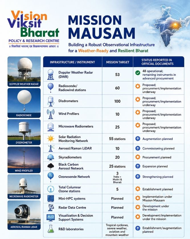
Under the mission, the government has targeted the commissioning of 53 such radars, alongside 60 Radiosonde/Radiowind stations that sample the upper atmosphere using instrumented weather balloons, 100 disdrometers that measure the size and speed of individual raindrops to distinguish a gentle shower from the kind of intense downpour that triggers flash floods, 10 wind profilers that track wind behaviour at different altitudes, and 25 microwave radiometers that fill in atmospheric moisture and temperature detail satellites can miss. An enlarged Solar Radiation Monitoring Network, new Aerosol and Raman LiDAR installations, additional Skyradiometers, a strengthened Black Carbon Aerosol Network, and new ozone-monitoring stations both within India and at the Maitri and Bharati research stations in Antarctica. According to the government’s most recent public reporting, delivered to the Lok Sabha in March 2026, 48 of the 53 targeted radars were already operational, with the remainder of the equipment list in advanced stages of procurement.
Instrument and Infrastructure Status
-
Establishment of the computing power
India’s two dedicated meteorological supercomputers, Pratyush and Mihir housed at IITM and NCMRWF respectively, and together delivering roughly 6.8 petaflops of processing capacity since their 2018 commissioning already run the country’s seasonal, medium-range, and short-range forecasting models. Mission Mausam adds new mini–High-Performance Computing Systems, a dedicated Radar Data Centre to absorb the flood of new observational data, and Visualization and Decision Support Systems that turn raw model output into usable, real-time hazard maps.
-
Manpower development
New R&D laboratories are being established for tropical cyclones, severe weather, aviation meteorology, and mountain weather, alongside expanded training facilities for the scientists and technicians who will operate this larger, more complex network with a recognition that hardware alone does not improve forecasts without the people trained to interpret it.
-
Delivering Improved Weather Forecasts Directly to Citizens
The “Mausamgram” (Har Har Mausam, Har Ghar Mausam) platform delivering hyperlocal, village-level forecasts with hourly updates for the next 36 hours, three-hourly forecasts for the following five days, and six-hourly forecasts out to ten days searchable by PIN code, location name, or by state, district, block, and gram panchayat, and available in every official Indian language. The second is the Web-GIS based Multi-Hazard Early Warning Decision Support System, built entirely in-house by IMD rather than licensed from an overseas vendor. The government has quantified the savings from that choice explicitly: an estimated ₹250 crore avoided in acquisition costs and ₹5.5 crore in annual maintenance fees, framed directly under the Atmanirbhar Bharat banner. The system went on to win the National Award for e-Governance 2025.
Turning Weather Forecasts into Actionable Decisions
The real value of Mission Mausam lies in converting improved weather observations and forecasts into sector-specific, actionable advisories. For agriculture, better monsoon and short- to medium-range forecasts can support decisions on sowing dates, irrigation scheduling, crop management, and yield planning. They can also strengthen existing crop-insurance mechanisms that depend on localized weather observations, potentially improving the accuracy and timeliness of farmers’ compensation claims.
For water resources, improved seasonal and extended-range forecasts can assist state authorities in reservoir operations, water allocation, and irrigation planning. In disaster management, Mission Mausam’s forecasts and warnings feed into established dissemination systems involving State Emergency Operation Centres and district administrations, helping authorities prepare for events such as floods, cyclones, and severe storms.
The mission also identifies energy and public health as important application areas, although these advisory systems are comparatively less developed. Overall, Mission Mausam seeks to move beyond simply predicting weather to translating forecasts into timely decisions that protect livelihoods, infrastructure, and communities.
A Targeted Focus on the Northeast
Among India’s regions, the government has singled out the Northeast for specific attention within the mission, citing the frequency of monsoon flooding and rainfall-triggered landslides that threaten both livelihoods and infrastructure there. The response has three parts: deploying observation systems specifically adapted to hilly terrain, where standard radar coverage assumptions do not hold; delivering forecasts detailed enough to warn communities before, not after, flooding and landslides occur; and working directly with state governments to integrate weather data into their existing disaster-management planning.
The engineering reality behind this focus is straightforward: a radar placed on open, flat terrain can see storm systems developing across a wide, largely unobstructed radius, while a radar placed among ridges and mountains has its effective range broken up by the very landscape it needs to monitor. Covering the Northeast to the same standard as the Gangetic plains therefore requires either a denser radar grid or more carefully chosen sites that trade horizontal range for vertical line-of-sight with a costlier proposition per square kilometre of effective coverage than deployment almost anywhere else in the country. This region-specific commitment reflects an honest acknowledgement, echoed in the government’s own list of challenges facing the mission, that India’s geographical diversity and its uneven infrastructure gaps require deliberate, targeted investment rather than an assumption that national progress will reach every region evenly.
Mission Mausam Contributes to Viksit Bharat @2047
Mission Mausam sits inside a larger architecture. It is explicitly designed as the operational foundation for IMD Vision 2047, and through that document, it connects directly to the government’s wider Viksit Bharat @2047 framework with the national vision, coordinated by NITI Aayog. Mission Mausam contribution to this vision runs along several distinct lines.
Strengthening the Annadata: Accurate and timely weather forecasts help farmers make better decisions on sowing, irrigation, and harvesting. Mausamgram extends such information to village and gram-panchayat levels in Indian languages.
Protecting Development Gains: Improved warnings and longer forecast lead times can reduce the economic losses caused by cyclones, floods, heatwaves, and other extreme events, protecting livelihoods and infrastructure.
Advancing Atmanirbhar Bharat: The development of indigenous meteorological technologies, including the in-house Multi-Hazard Early Warning Decision Support System, strengthens India’s capacity for self-reliance in advanced weather technologies.
Extending Digital India to Weather Services: Multilingual and location-specific platforms such as Mausamgram bring weather information closer to citizens, supporting the government’s vision of accessible and inclusive digital public services.
Strengthening Disaster Management: Mission Mausam integrates improved forecasts and warnings with disaster-management authorities, enabling governments and communities to prepare earlier and respond more effectively to severe weather.
Building Scientific and Industrial Capacity: Investment in research, training, indigenous instruments, sensors, and software development strengthens India’s scientific workforce while creating opportunities for collaboration among institutions, academia, and industry.
Supporting Aviation and Transport: Better forecasting of fog, visibility, thunderstorms, and other hazardous conditions can support safer and more efficient aviation and transportation operations, particularly during periods of severe weather.
Strengthening the Maritime Economy: Through ocean-focused institutions and observations, Mission Mausam supports marine forecasting and weather information for activities such as fishing, shipping, ports, and offshore operations.
An Enabling Mission for Viksit Bharat: Collectively, these interventions make Mission Mausam an enabling component of the Viksit Bharat @2047 vision by strengthening agriculture, disaster resilience, digital governance, transport, maritime activities, and scientific capacity through better weather intelligence.
